|
|||||||||||||||
|
| |||||||||||||||
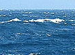
Winter storms fade out April marks the tail end of the winter storm season on the Central Coast. By April, sunny, breezy days become the norm rather than the exception. It's easy to believe that spring has finally arrived in earnest. It's also easy to anticipate that point in the year when you can be pretty sure it won't rain for another six months. But as soon as you plan that April picnic or camping trip, a late storm sneaks down the coast, bringing at very least a heavy drizzle, and at worst, enough real rain to make you wish you had packed a real raincoat. In between these late storms, you can usually count on plenty of sunny days and gusty northwest afternoon winds, especially along the coast. April mornings typically dawn clear and chilly, with a cold breeze blowing down the coastal canyons and out to sea. By around 10 or 11 AM, however, the wind switches and begins to blow in from the sea. By 1 PM the northwest wind has built to half a gale and the sea surface is churned by whitecaps and short-period wind waves. This howling wind continues until nightfall, and sometimes blows on through the night. Note: Beyond 5 or 10 miles offshore, the land breeze has less effect, and northwest winds often howl throughout both day and night. 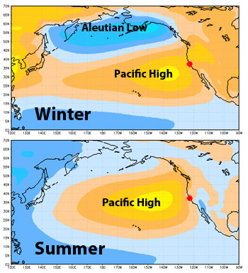 This illustration shows how the Pacific High expands and the Aleutian Low contracts between winter (top) and summer (bottom). The red dot indicates the location of the Central California Coast. (Source: NOAA/NCDC) The northwest winds of spring are driven by two meteorological processes—one regional and the other local. On a regional scale, low pressure systems (late winter storms) are dropping south from the Gulf of Alaska and then moving eastward over Oregon and Northern California. Meanwhile, a large area of high pressure (the Pacific High) is strengthening and expanding northward between California and Hawaii. Strong winds are generated along the boundaries between the low-pressure systems and the Pacific High. On a local scale, these large-scale northwest winds are affected by local topography. During the evening and early morning hours, cool air from the land flows down the coastal valleys and out over the coastal ocean. This "land breeze" counteracts the regional northeast winds, creating calm or offshore conditions at the coast. As morning changes to afternoon, the air over the land is heated by the sun and begins to rise. This pulls cool air from the ocean toward shore, accentuating the regional northwesterly winds. Upwelling kicks into high gear Along the Central Coast, northwest winds may blow briefly at any time of year, but they are strongest and most consistent in late April or early May. These winds push the surface waters offshore, allowing cold, nutrient-rich water to rise up from the depths—a process called upwelling. During April, strong upwelling events may continue for weeks at a time. Note: When northwest winds die down, the cold upwelled water at the surface near the coast immediately begins to sink. This draws surface waters back toward shore, creating what are known as "relaxation events." 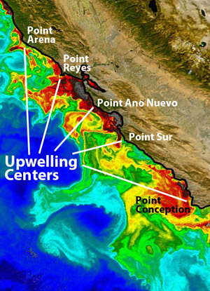 Upwelling centers along the Central California Coast. (Source: Modified from NASA Images) Upwelling is not evenly distributed along the coast. It is most intense near points of land that jut out from the coast, such as Point Arena, Point Reyes, Point Año Nuevo, and Point Sur. When upwelling continues for more than a few days, cold upwelled water begins to flow away from these "upwelling centers." The resulting plumes of cold, nutrient-rich water may be 180 feet thick, 50 miles long, and several miles wide. Sometimes these plumes of upwelled water form long narrow "jets" that flow rapidly away from the coast. At the peak of the upwelling season, such jets may travel more than one hundred miles out from the coast. The cold upwelling jets gradually weaken and begin to form meanders and eddies as they mix with the southward flowing, warmer water of the California Current. Plumes of cold, nutrient-rich water also flow toward the southeast along the coast. During the peak upwelling months of April and early May, upwelling plumes bring some of the coldest water of the year to exposed coastal areas. Such cold water usually comes in pulses that last from one to five days. As they move parallel to the coast, these near-shore upwelling plumes sometimes begin to meander from side to side. Thus, the Año Nuevo upwelling plume alternately sends bursts of cold water into Monterey Bay and then down along the Big Sur coast. Similarly, the plume of cold water from the Point Reyes upwelling center alternately flows into the Gulf of the Farallones and then just offshore of the Farallon Islands. |